 |
| Panoramic view of the shore at Tuas |
Wednesday, December 24, 2014
First visit to Tuas Merawang
Yesterday evening, a group of shore explorers went to check out the shore at Tuas.
We are very grateful for the kind staff at MSD Pharma (Singapore) Pte Ltd, who helped to make this trip possible.
Sunday, June 15, 2014
The Amazing Frog Island, Round 2
We are back at Sekudu again for the second survey trip with a difference of two days. This time, I get to see the whole island in daylight as we worked past sunrise. Even a second visit within such a short time span can bring interesting findings such as this shortnose boxfish (Rhynchostracion nasus), which is the time time I am seeing it.
The boxfish has a very tough boxy body. It was so intriguing to feel its boxy body. Having said that, we should not be touching marine animals on the shore as some of them do sting or are poisonous to us.
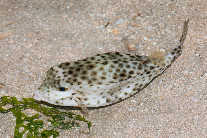 |
| Shortnose boxfish |
Friday, June 13, 2014
The Amazing Frog Island
Did you know that Singapore has an island called Frog Island? The Malay name for this island is known as "Pulau Sekudu". In Chinese, it is called 青蛙岛.
Pulau Sekudu is an small island located just south of Chek Jawa, Pulau Ubin. It is a restricted area and permit from the National Parks Board (NParks) is required to gain access to this island.
The Google map above show you the location of Pulau Sekudu (south of Pulau Ubin, north of Changi Village).
Monday, June 2, 2014
Coral bleaching situation at Terumbu Pempang Laut
Recently, the tropical region is on high alert on coral bleaching as the water temperature in this region is getting warmer.
Here is the bleaching alert of Singapore and her neighbouring waters from Coral Reef Watch.
From the image, Singapore is located in middle of a Watch zone and Alert Level 1 zone.
Here is the bleaching alert of Singapore and her neighbouring waters from Coral Reef Watch.
 |
| Bleaching alert in the Southeast Asia region [Image from Coral Reef Watch] |
Sunday, June 1, 2014
My first visit to Terumbu Pempang Laut
It has been about 3 months since I last did an amphibious landing on our intertidal shores. The previous trip was to Pulau Semakau to check on the oil spill situation during the Lunar New Year. Today, we are doing an amphibious landing on one of the terumbus we have in Singapore. Terumbu refers to submerged reef. During high tide, it looks no different from any sea surface. The reef is being submerged. However, during the period of low spring tide, the tide falls below the reef, exposing the reef. It looks as though a piece of land has emerged from the sea and sank back a few hours later.
So where exactly is Terumbu Pempang Laut? Take a look at this google map image by Ria Tan.
From the image, you can see that Terumbu Pempang Laut is the furthest submerged reef northwest of Pulau Hantu. This is my first time visiting this reef. I have yet to visit Terumbu Pempang Tengah and Terumbu Pempang Darat.
So where exactly is Terumbu Pempang Laut? Take a look at this google map image by Ria Tan.
 |
| Image from Ria Tan. |
[Update] Welcome to my new blog URL
Hello!
Welcome to my "new" blog. As you have noticed, it is only a change in the blog's URL.
Thank you for reading my wonderful posts about Singapore's marine life.
Singapore GOT wildlife.
Cheers,
Pei Yan
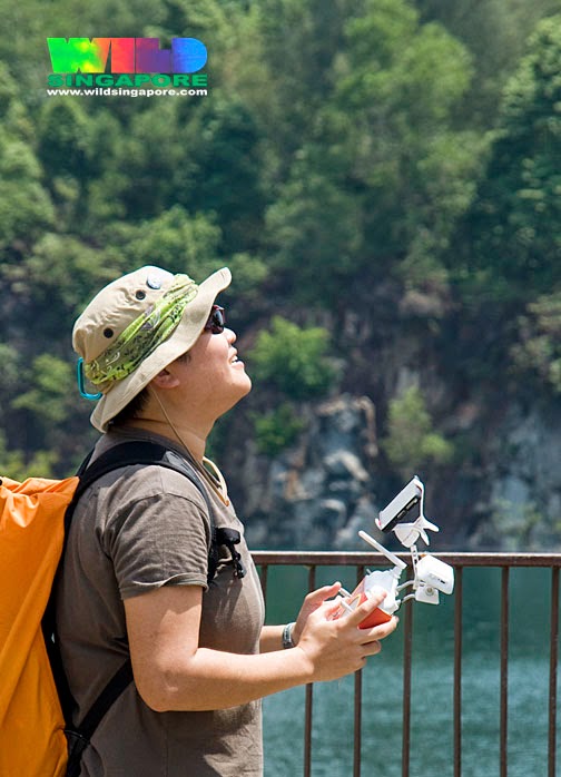 |
| Photo of me flying the drone by WildSingapore (Ria Tan). |
Thursday, May 29, 2014
Saving Changi Crabs
On this very morning, something upsetting happened at one of the beaches in Changi. Just as my friends and I were about to end our intertidal survey, we found a 50m driftnet. It is unsure how long the driftnet had been laid.
It took us plenty of patience and skills to untangle and cut free the trapped marine animals from the net.
In total, we counted 40 flower crabs, 1 stone crab, 1 stingray, 1 horseshoe crab, 1 flounder and some decomposed fish.
 |
| Looking at the driftnet after we brought it in in sections. [Photo from Project Driftnet] |
 |
| Working hard and carefully to free the tangled flower crabs from the net. [Photo from Project Driftnet] |
Monday, May 19, 2014
I'm a human climbing crab at Tanah Merah Ferry Terminal
When I mention "Tanah Merah Ferry Terminal", what will you relate it to? Ferries, Golf, Resorts, Bintan, overseas, travelling, holiday.
Do you know that as you walked along the jetty to your ferry, you had actually just walked over a reclaimed areas that has transformed into a beautiful coral garden? Corals, where are they? They are actually right at the base of the seawall.
I covered a different stretch of the coral garden on this trip to the shore near Tanah Merah Ferry Terminal.
Do you know that as you walked along the jetty to your ferry, you had actually just walked over a reclaimed areas that has transformed into a beautiful coral garden? Corals, where are they? They are actually right at the base of the seawall.
 |
| Beautiful coral garden at Tanah Merah Ferry Terminal [Photo by Loh Kok Sheng] |
Saturday, May 17, 2014
New signs of life on Changi Beach
Right after a three day Leafmonkey workshop "Walking with Nature at SOTA", some of us only had a few hours of sleep before we head out for another session with nature. The only difference is that we do not see people, but marine animals on our intertidal shores. The location: Changi Beach.
The stretch of shore we covered on this trip is full of new life. I came across so many juvenile animals such as this seagrass pipefish. You can tell how small it is by comparing the pipefish with the size of the spoon seagrass (Halophila ovalis).
I came across another juvenile seagrass pipefish later.
The stretch of shore we covered on this trip is full of new life. I came across so many juvenile animals such as this seagrass pipefish. You can tell how small it is by comparing the pipefish with the size of the spoon seagrass (Halophila ovalis).
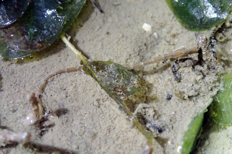 |
| Juvenile seagrass pipefish |
Tuesday, May 13, 2014
Ubin Tua Pek Kong Celebration - Day 1
Yesterday was the first day of a 6 days celebratory festival of Pulau Ubin Fo Shan Ting Da Bo Gong Temple (Tua Pek Kong). Everyone is welcome to this celebratory event and there is event free bumboat service provided in the evening for all 6 days.
 |
| Notification banner at Ubin jetty. |
At Changi Point Ferry Terminal, the same banner is placed outside Ubin Seafood Restaurant, next to the ferry terminal. While at the drop-off point of the ferry terminal, the schedule of events and free bumboat services is displayed.
Wednesday, May 7, 2014
The beauty of Pulau Hantu
Many people will relate 'Hantu' as the Malay word for ghost and hence the island Pulau Hantu is literally referred to as "Ghost Island". The island is actually far from the spooky tales and myths of restless spirits or ghosts.
The whole of Pulau Hantu is formed by two separate "Hantu" islets - Hantu Besar (Big Ghost) and Hantu Kechil (Little Ghost).
 |
| Pulau Hantu looks tiny compared to its refinery neighbour, Pulau Bukom. Image from Google earth. |
Thursday, May 1, 2014
Drone-ing Kusu Island
Located on one of Singapore's southern islands is this beautiful jetty and Chinese temple.
 |
| Panoramic view of the jetty |
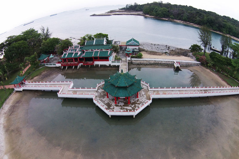 |
| Chinese Temple |
Where am I?
Tuesday, April 29, 2014
12 May - 17 May 2014: Pulau Ubin Celebrates the Tua Pek Kong's birthday
Have you ever wondered what this interesting structure (left, photo below) at Ubin town is used for?
From 12 May to 17 May 2014, this stage will be transformed into a wayang (chinese opera) performance stage, showing Teochew opera.
 |
| A stage seen at Ubin town. [Photo by WildSingapore] |
Sunday, April 20, 2014
Quiet but great day guiding at Pulau Hantu
It was a quiet day on the intertidal shore at Pulau Hantu. Despite that we still managed to find interesting stuff for the youths of Jurong Spring Youth Club. I was helping The Hantu Bloggers as a guide.
Here's a group photo of the youth participants with the four guides. Joining us on the trip is Minister of State Desmond Lee.
Here's a group photo of the youth participants with the four guides. Joining us on the trip is Minister of State Desmond Lee.
 |
| Group photo [Photo by MOS Desmond Lee on his Facebook] |
Sunday, February 2, 2014
Northern Beauty of Semakau
It was my first time checking the northern reef of Semakau. It was also the team's first time covering the whole reef of Semakau through a team effort.
Another team check the submerged reef next to Semakau's western reef, Terumbu Raya.
 |
| Pink line marks the reef coverage the team covered on this trip. |
Saturday, February 1, 2014
Oil spill reaches Pulau Semakau
On 29 January 2014, the Maritime and Port Authority of Singapore (MPA) released a media statement about a collision between the departing Hong Kong-flagged chemical tanker, "Lime Galaxy" and the arriving China-flagged containership, "Feihe" in the evening at about 2.7 km, south of Jurong Island.
The media statement reported that "Feihe" sustained damages on her bunker tanks, resulting in some spillage of bunker fuel. Oil spill response companies were activated to support in the clean up efforts.
It is not revealed the exact location of the collision as Jurong Island is rather large but the image below shows the possible locations, mapped out by Ria Tan (wildsingapore).
The following day, 30 January 2014, MPA released another update about the collision: Collision between Lime Galaxy and Feihe - update 1
The media statement reported that "Feihe" sustained damages on her bunker tanks, resulting in some spillage of bunker fuel. Oil spill response companies were activated to support in the clean up efforts.
It is not revealed the exact location of the collision as Jurong Island is rather large but the image below shows the possible locations, mapped out by Ria Tan (wildsingapore).
 |
| Possible locations of the collision, mapped by Ria Tan. |
Kusu Reef: A reef with the lion city view under lots of stress
The reef at Kusu Island is rather unique. It is one reef that has a special view - The cityscape of Singapore. This view can be reach with a 15 mintues ferry ride from Marina South Pier.
Kusu Island is managed by Sentosa. All visitors are required to pay an entrance fee of SG$0.50 upon arrival at the island. On this island, there is a chinese temple and three Kramats. You can read more about Kusu Island here.
 |
| Kusu reef with Singapore's cityscape in the distance. |
Friday, January 31, 2014
Kusu Island Oiled
On the eve of lunar new year, the Maritime and Port Authority of Singapore (MPA) release a media statement regarding 'Contact between vessels NYK Themis and AZ Fuzhou' - MPA News centre, 30 January 2014.
A collision between the vessels happened at East Keppel Fairway at about 4 km south of Marina South. "NYK Themis" is a Panama-flagged containership while "AZ Fuzhou" is a barge being towed by "AZ Carnation". Here's a estimated location mapped out by Ria Tan (wildsingapore) to show collision spot.
 |
| Estimated collision site |
Saturday, January 25, 2014
My love for TMSI-SJI
The Tropical Marine Science Institute, TMSI in short, is an institution formed with the National University of Singapore (NUS). The institution aims to play a strong role in promoting integrated marine science, in research and development, as well as to establish itself as a regional and international education and training centre through active collaboration with academic, government and industrial sectors. Major research areas in TMSI are Marine Environmental Management; Underwater Remote Sensing and Oceanography.
There are two TMSI research facilities - one located on the main campus of NUS at Kent Ridge while second is located off mainland Singapore at St. John's Island (SJI). The institution also has research vessel, Galaxea, allowing researchers to conduct experiment in Singapore waters.
 |
| TMSI homepage www.tmsi.nus.edu.sg |
 |
| The Galaxea [Image from TMSI's webpage, http://www.tmsi.nus.edu.sg/research-facilities-galaxea] |
Saturday, January 4, 2014
A new year, a new life on Chek Jawa
The new year marks the start of a slow progression towards intertidal fieldtrips as the low tide period starts to get lower and shifts from evening low tides to morning low tides. It is a great feeling to be back on the shore again, after about 1.5 months break due to the unfavourable low tides since mid November last year.
The first intertidal fieldtrip of 2014 begins at Chek Jawa. With heavy rain pouring almost daily throughout November to December and the eastern part of peninsular Malaysia being hit by floods, we were worried if Chek Jawa will be affected by large amount of freshwater flowing down the Johor river. Chek Jawa is located on the eastern end of Pulau Ubin where discharge from the nearby Johor River is directed at.
The first intertidal fieldtrip of 2014 begins at Chek Jawa. With heavy rain pouring almost daily throughout November to December and the eastern part of peninsular Malaysia being hit by floods, we were worried if Chek Jawa will be affected by large amount of freshwater flowing down the Johor river. Chek Jawa is located on the eastern end of Pulau Ubin where discharge from the nearby Johor River is directed at.
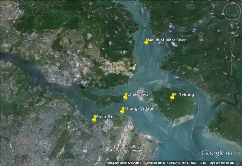 |
| Location of Johor River mouth. |
Subscribe to:
Posts (Atom)